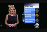
interior north bay, napa valley, mid-to-upper 40s there. 44 degrees in antioch overnight tonight, 51. here's the setup for the next few days. high pressure will continue to build in. you can see what it's doing, just pushing the jet stream or the area of storminess well to the north of the bay area. so no rain in our accuweather seven-day forecast. it will keep us clear tonight as well as tomorrow and as we head into monday and tuesday, this high will really start and peak and push inland and that's going to mean peak temperatures, the warmest temperatures, monday and tuesday. and we're talking daytime highs close to 90 degrees especially inland. so a possibility of record highs. here's how we'll look tomorrow. you can see for oakland, 75 degrees. by monday, temperatures start to come up. low 80s. and then as the sea breeze moves in, temperatures drive back down into the 60s, livermore valley area, 87 for sunday. notice the warmest day, monday, close to 90 degrees, through tuesday, and then cool off by thursday, friday, and saturday, so enjoy the warmup. warmer by as much as three to
 Live Music Archive
 Librivox Free Audio
 Metropolitan Museum
 Cleveland Museum of Art
 Internet Arcade
 Console Living Room
 Books to Borrow
 Open Library
 TV News
 Understanding 9/11